Southern California’s geography—steep canyons, narrow mountain roads, and dense urban development pushed against wildland—makes wildfire evacuation uniquely challenging. During the 2025 fire season, traffic gridlock during evacuations endangered thousands of residents who had only one road out. Planning your evacuation routes before a wildfire strikes is not optional in Southern California—it is a life-saving necessity. This guide covers evacuation route planning for Los Angeles, San Diego, Riverside, San Bernardino, and Ventura Counties.
Why Southern California Evacuation Is Different
Several factors make SoCal wildfire evacuations more complex than anywhere else in the state:
- Population density: Millions of residents in the wildland-urban interface (WUI) means massive simultaneous evacuation demands
- Canyon communities: Many neighborhoods have only one or two roads in and out
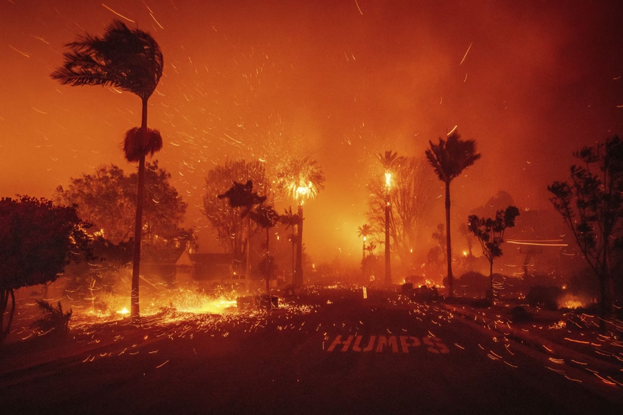
- Santa Ana winds: Fire spreads at extreme speeds during wind events, reducing evacuation time to minutes
- Traffic congestion: Even normal SoCal traffic is among the worst in the nation—add panic and it becomes paralyzing
- Road closures: Fire can cut off primary evacuation routes, forcing real-time rerouting
Wondering if your property is in a high-risk fire zone? Check your wildfire risk score to see your CAL FIRE zone and exposure level based on your address.
Planning Your Primary Evacuation Routes
Every Southern California household in a fire-prone area should identify three evacuation routes:
Route 1: Direct Highway Access
Your primary route should be the fastest path to a major freeway or highway. In most SoCal communities, this means reaching the I-5, I-10, I-15, I-210, SR-118, or SR-14 corridor. Know which freeway on-ramp is closest to your home and which direction you should travel (away from the fire).
Route 2: Alternate Surface Streets
If your primary route is blocked or gridlocked, know alternate surface streets that bypass the congestion points. Major boulevards and arterials are preferable to small residential streets, which can become bottlenecked.
Route 3: Emergency Back Roads
Identify at least one back-road option. In canyon communities, this might mean knowing which fire roads or utility access roads exist as emergency alternatives. While these are not ideal driving conditions, they can be life-saving when primary and secondary routes are blocked.
Not sure which step to prioritize first? Our wildfire risk calculator shows your CAL FIRE zone and exposure level — so you know exactly where to start.
County-Specific Evacuation Considerations
Los Angeles County
LA County’s WUI communities—Malibu, Topanga Canyon, Pacific Palisades, the San Gabriel foothills, and the Santa Clarita Valley—face unique evacuation challenges:
- Malibu and Topanga: Pacific Coast Highway (PCH) is often the only exit. During the Woolsey Fire, PCH became a parking lot. Know alternate routes through Topanga Canyon and Mulholland Highway
- San Gabriel foothills: Communities like La Canada Flintridge and Altadena rely on foothill boulevards to reach the I-210. Know multiple access points to the freeway
- Santa Clarita: The I-5 and SR-14 are primary escape routes. During large fires, both can be affected simultaneously
San Diego County
San Diego’s fire-prone communities include Rancho Santa Fe, Ramona, Julian, Valley Center, and the eastern suburbs:
- Backcountry communities: SR-67, SR-78, and SR-79 are critical evacuation corridors. These two-lane highways can become extremely congested
- Rancho Santa Fe and Del Dios: Limited road network requires early evacuation decisions
- I-15 corridor: Communities from Escondido to Fallbrook depend on I-15 access
Riverside and San Bernardino Counties
The Inland Empire’s WUI extends into the San Bernardino National Forest and surrounding foothills:
- Mountain communities: Big Bear, Lake Arrowhead, and Running Springs have limited evacuation routes through mountain passes
- SR-18 and SR-138: Critical mountain evacuation corridors that can be cut off by fire
- I-15 Cajon Pass: Major bottleneck during large-scale evacuations
Ventura County
Ventura County’s fire history includes the Thomas Fire, which burned over 280,000 acres:
- Ojai Valley: SR-33 and SR-150 are primary routes with limited alternatives
- Santa Rosa Valley and Moorpark: Rely on SR-23 and SR-118 for evacuation
- US-101 coastal corridor: Can be cut off by fires in the hills above
Editor’s note: Your insurance situation depends heavily on your property’s actual fire exposure. Our free risk assessment factors in official CAL FIRE data to show what your risk level actually is — useful context before talking to your carrier.
Real-Time Information During Evacuations
During an active evacuation, information is as important as your route plan:
- County emergency alerts: Sign up for your county’s alert system (LA County uses AlertLA, San Diego uses AlertSanDiego)
- Waze and Google Maps: Show real-time traffic and road closures during evacuations
- CAL FIRE Twitter/X: Real-time fire updates and road closure information
- Local radio: KNX 1070 (LA), KOGO 600 (San Diego) provide continuous emergency coverage
- Scanner apps: Listen to fire and police communications for real-time route information
Evacuation Timing: When to Leave
In Southern California, the question is not whether to evacuate but when:
- Red Flag Warning issued: Begin pre-evacuation preparation. Load vehicles, review routes
- Evacuation Warning: Leave immediately if you are elderly, have medical needs, or have animals to transport. Do not wait for an Order
- Evacuation Order: Leave now. Take your go-bag and follow your planned route. Do not delay
During Santa Ana wind events, fires can overrun communities in minutes. The 2025 fire season demonstrated that waiting for an official Order can be too late. If you see smoke or flames and an Evacuation Warning has been issued, leave early.
Vehicle Preparation for Evacuation
- Keep your gas tank at least half full during fire season (September through December for Santa Ana winds)
- Park vehicles facing outward in the driveway for quick departure
- Keep a go-bag, water, and N95 masks in your vehicle year-round
- If you have an EV, maintain at least 80% charge during Red Flag Warnings
- Know how to manually open your garage door if power fails
Preparing Your Home Before Evacuation
Proper defensible space and home hardening give your home the best chance of surviving while you are away. Before leaving:
- Close all windows, doors, and vents
- Remove combustible items from around your home
- Leave interior and exterior lights on for firefighter visibility
- Shut off gas at the meter
- Leave a ladder accessible for firefighters
Ember Pro’s Role in Evacuation Preparedness
While Ember Pro cannot change your evacuation routes, we can ensure your home is prepared to survive while you are away. Our wildfire defense systems provide active protection during the critical hours when you are evacuated and cannot defend your property. Combined with proper defensible space and home hardening, our systems significantly increase your home’s survival odds.
Frequently Asked Questions
What if there is only one road out of my community?
Single-access communities are the highest risk for evacuation. Leave at the Evacuation Warning stage—do not wait for an Order. Contact your local fire department about emergency access routes that may be available during fires.
Should I use navigation apps during an evacuation?
Yes, but with caution. Apps like Waze show real-time conditions but can route you toward danger. Always evaluate whether a suggested route takes you toward or away from the fire before following it.
What if roads are blocked and I cannot evacuate?
If all routes are blocked, shelter in place in the most fire-resistant structure available. Stay inside, close all openings, and call 911. A well-hardened home with proper defensible space can survive most wildfire events.
How early should I start evacuating during a Santa Ana wind event?
During Red Flag Warnings with Santa Ana winds, begin evacuation preparation immediately. If an Evacuation Warning is issued, leave within 30 minutes. Do not wait for an Order during wind-driven fire events.
Can I evacuate to a friend’s house?
Yes, and it is preferable to evacuation shelters. Identify at least two friends or family members outside fire-prone areas who can host you during evacuations.
References
- CAL FIRE – Southern California Evacuation Planning Resources
- Los Angeles County Office of Emergency Management – Evacuation Routes
- San Diego County Office of Emergency Services – Ready San Diego
- Caltrans – Real-Time Traffic and Road Closure Information
- California Governor’s Office of Emergency Services – My Hazards Map
- USDA Forest Service – Wildland-Urban Interface Evacuation Studies
Related Articles
- Complete Guide to Defensible Space in California
- Wildfire Defense Systems for California Homes
- Home Hardening Strategies for Wildfire Protection
- Wildfire Insurance: What California Homeowners Need to Know
- California Wildfire Laws 2026: What Changed
Ember Pro helps Southern California homeowners prepare their properties for wildfire so that evacuation is a temporary measure, not a permanent loss. Contact us today for a professional wildfire risk assessment and defense system consultation.
Curious about your property’s actual wildfire risk? Our free calculator shows your CAL FIRE zone, exposure level, and recommended next steps based on your address.
Get your free risk score